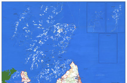
A contemporary artwork depicting a map of the UK shows a dystopic view of the UK post-Brexit, a humorous but stark reminder of a country steeped in division, and huge areas ‘drowned by Brexit’.
The work, produced by artist Stephen Walter and known as ‘Brexitland, 2019’, shows a nation physically defined by the 2016 EU Referendum – with the areas that voted Leave still part of the UK but those districts that voted Remain flooded by the sea. The map has joined more than 50 historic and contemporary maps in the Bodleian Libraries’ current exhibition, Talking Maps.

The 200 x 140cm work is a visual reflection of the 2016 EU Referendum election results. Having commissioned the printing of a bespoke map showing the district boundaries used for the referendum, artist Walter spent four months laboriously hand painting over it with watercolours.
Across the map many of the place names of ‘Brexitland’ appear with letters painted-out, to reveal new words that directly reference Brexit itself, and others that evoke negative connotations brought on by it. Many of the ‘South’ names have had the ‘S’ and the ‘H’ removed to reveal ‘out’.
Those areas of the UK that voted 60% or above for Leave are marked red on the map and district boundaries are also drawn in red to add to the sense of division:
- With the highest Leave count in the UK at 75.6%, Boston is the most prominent town on the map.
- The District of Chichester, surrounded by water on all sides, is now ‘The Cape of Chichester’.
- Deal in Kent is now ‘No Deal.’
Most dramatically the districts that voted 60% or above for Remain have been completely engulfed by the sea:
- Oxford, which voted 70.3% remain, is completely underwater.
- Scotland is immersed underwater creating new bodies of water like the ‘Strait of Edinburg’. Only Moray in the north, with a 50.1% vote to remain, is left as a tiny archipelago.
- Cardiff, which voted 60% for Remain, is now nothing more than a tideway.
- Wales has lost its north-western coastline of Gwynedd and Ceredigion, both of which voted for Remain. The western border of Powys now forms its coastline.
- Most of Northern Ireland is underwater with only its eastern districts left.
Many of the place names in these Remain areas now reference their new diluvial positions – the ‘Cotswold Wetlands’ [Oxford] and ‘Glasgow Caol’ [Glasgow]. Exeter is now a lagoon, Aberdeen is now ‘Aberdam’, as it looks towards its European cousin, and the capital is simply the “London Basin”.
Artist Stephen Walter said, “The ongoing political arbitration has caused a massive geographical shift away from the UK we all recognize, which is now undergoing a process of alteration and flux. Here, the concept has caused the alteration of place.” Brexitland follows on from recent works of Walter’s that explore the breaking down of place and the dismantling of traditional institutions.
Brexitland, 2019 appears in Talking Maps, an exhibition open until 8 March 2020 at the Bodleian Libraries, Oxford thatcelebrates maps and the stories they tell. The exhibition showcases iconic treasures from the Bodleian’s world-renowned collection of more than 1.5m maps, together with exciting new works on loan and specially commissioned 3D installations. Featuring ‘imaginary maps’ such Brexitland, 2019 as well as Grayson Perry’s Red Carpet and Map of Nowhere and J.R.R. Tolkien’s maps of Middle-earth, the exhibition offers a new perspective on the enduring power of maps.